It is known that the tourist area is vast, covering up to 8,425 hectares with numerous sightseeing zones. Therefore, without a map of Bana Hills, it would be challenging to imagine and explore this paradise fully. To assist visitors in confidently enjoying and experiencing Bana Hills, Vn Car Rentals’s will provide an updated and detailed map shortly.
Introduction to the latest map of Bana Hills
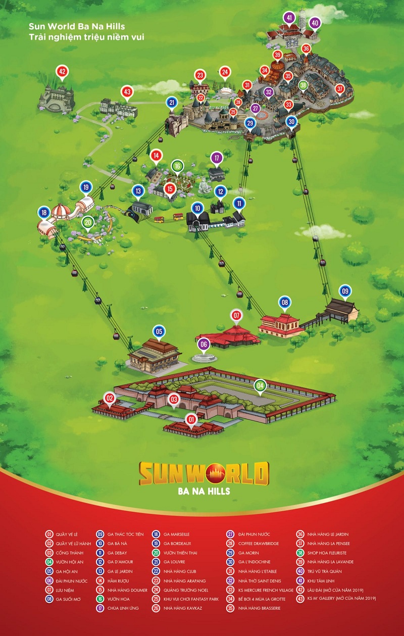
The Bana Hills map, also known as a layout, is a useful tool that clearly marks the famous attractions in Bana Hills. This helps tourists to envision what the tourist area offers and orient themselves to their current location. As a result, moving around becomes easier, and sightseeing becomes more convenient.
The Bana Hills map is quite detailed. It not only indicates the locations of stations but also provides the routes and lists all the famous landmarks in Bana Hills. It comes with specific explanations and illustrated images.
With the Bana Hills tourist map, you will undoubtedly feel confident in exploring the most attractive entertainment area in Da Nang. You can experience the four-season weather in a single day, immerse yourself in the beautiful scenery resembling a fairyland, and enjoy various captivating games…
When purchasing Bana Hills cable car tickets, you can request the ticket counter staff to provide you with a paper map for reference.
The map will introduce the location of Ba Na Hills tourist area
Before delving into the details of the areas in Ba Na Hills, let’s first explore the map to see where Ba Na is situated.
Where is Ba Na Hills located?
Ba Na Hills is a leading mountain resort in Da Nang. According to the Ba Na Hills map, it is located in the Truong Son mountain range, specifically on the peak of Mount Chua. It is part of An Son hamlet, Hoa Ninh commune, Hoa Vang district, Da Nang.
Being at an altitude of 1,489 meters above sea level, the climate here is cool and refreshing throughout the year, making it an ideal destination for family and friends to escape from the heat.
Reference: Ba Na Hills opening hours and recommended visit times.
How far is Ba Na Hills from Da Nang city center?
According to Google Maps, Ba Na is approximately 35 kilometers southwest of the city center of Da Nang. The travel time may vary from 45 minutes to 1 hour, depending on the starting location and mode of transportation.
To visit Ba Na Hills, tourists can choose to travel by car, taxi, motorbike, bus, or tour company shuttle. For those without much experience, joining a guided tour is an ideal option.
On the other hand, for those who are familiar with the Ba Na Hills map, they can opt for self-exploration by motorbike or other means of transportation.
You are looking for transportation to Ba Na Hills from Da Nang, and #VnCarRentals offers car rental services with private drivers from Da Nang to Ba Na Hills. With a professional team of drivers experienced in international passenger transportation, they will provide you with a quick and safe journey to Ba Na Hills.
The latest Ba Na Hills map on Google Maps
Most of the tourist attractions in Da Nang have their locations on Google Maps, and Ba Na Hills is no exception. If you have a smartphone, you can use the map on your phone to look up and explore.
With the Ba Na Hills map from Google Maps, travelers can easily navigate without worrying about getting lost. Just a few simple steps, input your starting location, and the destination is Ba Na Hills.
On this digital map, travelers can also zoom in and out to find transportation stations and recreational spots. Overall, it is very modern and user-friendly.
Details of the latest Ba Na Hills map regarding the main areas
Continuing with Vn Car Rentals’s, let’s explore the detailed map of the Ba Na Hills tourist area, focusing on the main regions. This will help travelers get an overview of the areas to visit and what each area has to offer.
Sun World Ba Na Hills Map – The Foot of the Mountain Area:
According to the Ba Na Hills map, this is the first location that visitors will encounter before reaching the peak of Mount Chua. Travelers will stop in this area to park their vehicles, buy cable car tickets, shop, or take a break.
The foot of the mountain area offers various entertainment options such as dining, shopping, and relaxation for tourists to experience. Some notable points of interest to visit include the Hoi An restaurant, Dream Stream, and Morin Station.
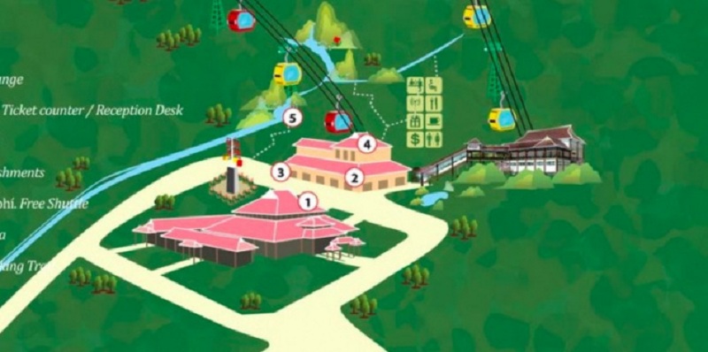
There are two main cable car lines here: the Ba Na Station Line, located in the middle of the mountain’s back, and the Morin Station Line at the higher altitude. To fully explore all points of interest without missing any, it is recommended to follow the Ba Na Hill area map from the bottom to the top. You can start from Ba Na Station and then proceed to Morin Station.
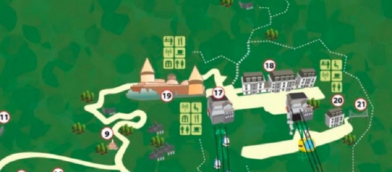
The Latest Ba Na Hills Map – Ba Na Station Area:
Ba Na Station is the next location that visitors will move to, situated on the mountain’s slope. It is also the area with the most top-notch entertainment and amusement offerings in Ba Na Hills. With a mix of ancient European colors and a touch of modernity.
Moreover, according to the 2025 Ba Na Hills map, the Ba Na Station area is also a spiritual destination. It takes tourists to a world of serene and ethereal spirituality with many other fascinating things to explore. Specifically, visitors will stop and visit prominent places here, such as:
- Ba Na Station – Transit point for passengers.
- Deby Station – Taking tourists to the spiritual area.
- Ba Temple – The first place to set foot after leaving Ba Na Station.
- Linh Ung Pagoda – The second Linh Ung Pagoda on the peak of Mount Chua.
- Thich Ca Buddha Statue – The largest Buddha statue in Southeast Asia.
- Meditation Garden – A tranquil space.
- Restaurant Area – Doumer Cafe.
- Le Jardin Cuisine Area.
- Debay Wine Cellar – A more than 100-year-old wine cellar of the French.
These are the key points on the latest Ba Na Hills map that travelers can explore to make the most of their visit.
Ba Na Hills 2025 Map – Morin Station Area:
Continuing with the Ba Na Hills Map, we have the Morin Station area. Here, visitors will find themselves in a vibrant, lively, and colorful space. This area is also the focal point of many attractions and exciting entertainment spots in Ba Na Hills.
Tourists will pass through the largest indoor amusement park in Vietnam – Fantasy Park, where they can experience a multitude of games of all kinds. Alternatively, they can indulge in health care and relaxation services at Morin Spa.
Furthermore, according to the 2023 Ba Na Hill map, visitors can also explore the famous Golden Bridge, a hot check-in spot both within the country and internationally, in this tourist area.
Ba Na Hills Sightseeing Map – Mountain Peak Area:
The mountain peak is the final area on the latest Bana Hills map that travelers will discover. This area stands at an altitude of 1,489 meters above sea level. It features the Linh Chua Linh Tu temple complex, Bell Tower, and Cosmic Wonderland,…
In general, the mountain peak area brings together the unique cultural and religious beliefs of the local people. Undoubtedly, this will be an ideal stop if you truly want to explore and experience the spiritual culture.
Map of the highlighted attractions at Ba Na Hills in 2025
If you look at the Ba Na Hills map from the foothill area to the mountain peak, you will find countless points of interest. Each location has its own beauty and charm. Below, Vn Car Rentals’s shares the most popular tourist spots on the Ba Na Hills map.
Golden Bridge Da Nang – The Hands Bridge:
First on the Ba Na Hills map is the Golden Bridge, also known as the Hands Bridge. It is constructed on the highest mountain of the Hoang Lien Son range, crossing the mountain’s back like a soft silk strip.

What makes it special are the giant hands that firmly support the bridge from a height of 1,400 meters, covered with mysterious moss. With this unique feature, the Golden Bridge has received recognition from numerous major newspapers. From here, visitors can admire the spectacular scenery of Ba Na, the vast mountains and forests, and have fantastic photo opportunities.
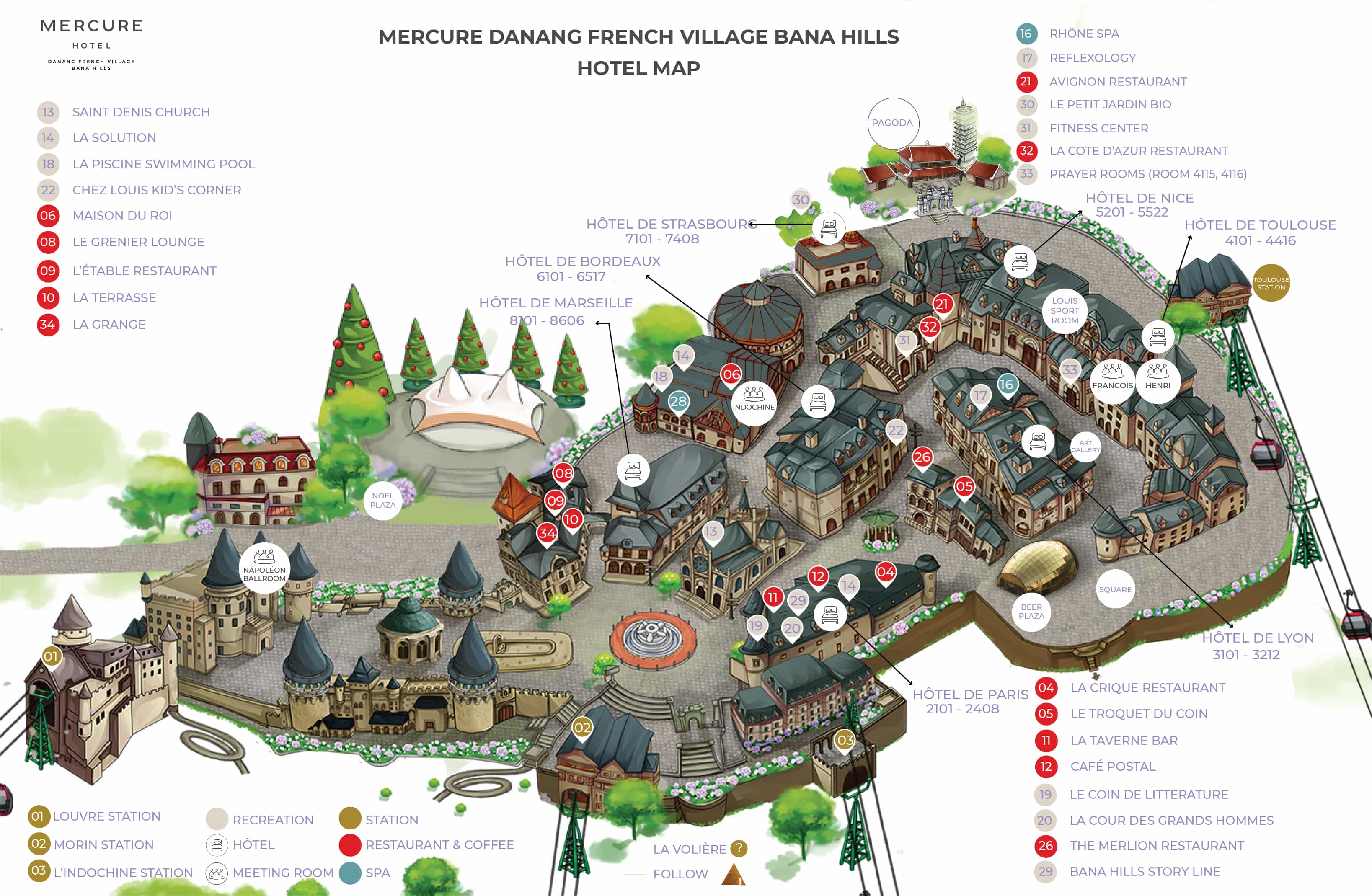
French Village Ba Na Hills:
The French Village is another outstanding spot on the Ba Na Hills map that no traveler should miss. It exudes a strong European style with ancient and romantic architecture.

Taking a stroll around the French Village, visitors can explore the square, the village, the church, and the castle, all grand and luxurious, yet retaining a dreamy and romantic atmosphere.
Le Jardin D’Amour Flower Garden:
The next destination on the Ba Na Hill sightseeing map, which VnCarRentals.com believes travelers will love, is the Flower Garden of Love. Le Jardin D’Amour features a French style with 9 themes, each associated with interesting stories.

Here, visitors can immerse themselves in the beauty of numerous vibrant flowers such as tulips, roses, dahlias, and cherry blossoms, making Ba Na Hills even more enchanting and romantic. This place is a favorite “photo spot” for young people.
Sun Square
This is a newly added location on the latest Ba Na Hills map in Da Nang. Sun Square is considered a perfect combination of Ba Na, a place where the Kingdom of the Moon meets the Kingdom of the Sun.

When visiting this area, travelers will feel as if they are embarking on a special journey. Besides the poetic scenery of clouds, sky, and mountains, Sun Square also has restaurants offering delicious cuisine for visitors to savor.
Moon Castle
Together with Sun Square, the Moon Castle is also a brand-new coordinate on the latest Ba Na Hills map. It promises to bring memorable experiences and emotions to visitors.

Here, visitors will immerse themselves in mysterious fairy tales and be captivated by unique and enigmatic architectural structures like the Dragon Cave, Moon Square,…
Fantasy Park Amusement Area
The Ba Na Hills map also includes Fantasy Park – one of the largest and most modern amusement parks in Vietnam. Spanning over 21,000m2, Fantasy Park offers more than 100 indoor and outdoor games, ranging from gentle experiences to adventurous and thrilling activities.

Some examples include the free fall tower, fairyland area, dinosaur park, century racetrack, 2D and 3D cinemas, and more. All of these await visitors to explore and enjoy.
Guide to fully exploring the latest Ba Na Hills Map
As you can see, Ba Na Hills is vast and consists of many areas with numerous points of interest to visit. If you haven’t been here before and don’t have the 2025 Ba Na Hills map, it can be challenging to fully experience this place. Therefore, Vn Car Rentals’s will guide you through the visit!
Getting to Ba Na Hills:
First, from the center of Da Nang city, travelers can choose the appropriate mode of transportation and start the journey along the route: Duy Tan Street – Nguyen Van Linh Street – Nguyen Tri Phuong Street – Dien Bien Phu Street – Ton Duc Thang/QL1A Street – Ba Na – Suoi Mo to reach Ba Na Hills.
In fact, travelers can also follow the guidance of the Ba Na Hills map on their phones, taking the route QL14A or DT602. However, the route mentioned above is the shortest and easiest one, preferred by many people.
Buying Ba Na Hills cable car tickets:
After arriving at the foothill area, travelers will park their vehicles and purchase tickets at the counter near the entrance. The ticket price is 950,000 VND for adults and 750,000 VND for children. Alternatively, travelers can book tickets in advance in Da Nang to avoid the hassle of queuing and waiting.
Starting the Ba Na Hills sightseeing itinerary:
Holding the tickets in hand, travelers will start the Ba Na Hills sightseeing itinerary according to the Ba Na Hills map, specifically:
- Move to Hoi An Station and take the cable car to the Golden Bridge area.
- After visiting the Golden Bridge, take the train from Le Jardin Station to D’amour Station to explore: Linh Ung Pagoda Ba Na, Flower Garden of Love, and Debay Wine Cellar.
- From the spiritual area, walk to Debay Station to take the cable car to the mountain peak, reaching the French Village. Explore the French Village, have fun at Fantasy Park, and visit the wax museum (self-cost of 100,000 VND/person).
- Travelers will hike to visit the Linh Chua Linh Tu Temple, Tru Vu Tra Quan – all locations mentioned in the Ba Na Hills tourist area map.
- After visiting all the prominent locations in Ba Na Hills, travelers will walk to L’Indochine Station to take the cable car down the mountain.
The journey to explore Ba Na Hills usually lasts the entire day, starting in the morning and ending in the afternoon. Travelers should plan their time accordingly for a fulfilling experience!
Answering frequently asked questions about the latest Ba Na Hills map.
As mentioned above, the Ba Na Hills tourist map is very useful, especially for first-time visitors. #VnCarRentals will now provide answers to some common questions:
Does the Ba Na Hills tourist map come in a paper version?
Yes, it does. The Ba Na Hills sightseeing map is usually provided at the ticket counter at the entrance. When purchasing tickets, you can ask the staff for a map. Rest assured, it’s free, and each visitor typically receives one copy (if needed).
Is the Ba Na Hills map easy to understand?
The paper map is detailed, containing all the areas, stations, points of interest, recreational spots, restaurants, hotels, and more. It provides plenty of information and comes with illustrated images, making it easy for you to visualize and plan your itinerary.
How long does it take to visit all the points on the Sun World Ba Na Hills map?
Based on VnCarRentals’ research, to explore all the prominent points on the Ba Na Hills map, it will take at least one day, from morning to evening. However, to enjoy the sightseeing and activities fully without rushing and to avoid missing any locations, you should carefully study the map and follow the instructions from the bottom to the top.
Tips for Using the Latest Ba Na Hills Map
The Ba Na Hills map gives you a complete overview of all stations, areas from the foothill to the mountain peak, and key attractions. This helps you navigate the tourist area with ease. To make the most of the map, keep these tips in mind:
As soon as you enter the gate, check the map to identify the main attractions and plan your itinerary accordingly.
- If you don’t have a physical map, visit banahills.sunworld.vn to access the latest digital map of the area.
Use a pen to mark the order of attractions you want to visit and the locations of stations to avoid getting lost.
If you’re unsure how to read the Ba Na Hills map or need help planning your route, consider booking a guided tour. A guide will provide clear directions and ensure you don’t miss any must-see spots.
Conclusion
With the Ba Na Hills map in hand, exploring this tourist paradise becomes easier and more convenient than ever. Navigate confidently without worrying about getting lost or missing any must-visit attractions. Use the Ba Na Hills map to ensure a complete and fulfilling trip.


[…] more detailed articles about the Bana Hills map: The latest map of Bana Hills includes various areas and sightseeing […]
[…] More: The latest map of Bana Hills includes various areas and sightseeing […]